|
|
The "Sovereign Flyover" |
|
|
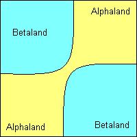
This is my own name (hence the quotes) for something which - I believe - had never actually been done in practice. It's just a theoretical construct that I read about. It usually gets dragged out each time you have a situation like Palestine in 1948, or Bosnia in 1992-1995, when people are talking about dividing a region into separate countries. It's never actually been done, because what inevitably happens is that while the UN talks, and the diplomats draw pretty little maps, the people concerned end up (for whatever reasons, I'm not making any point, please don't flame me) fighting a war to determine the boundaries. But it could happen, and if it did, it might make an interesting feature to throw into one of your campaign worlds. Let's create an imaginary country, Struggleland. Struggleland is home to two totally distinct ethnic and cultural groups, the Alphas, and the Betas. They don't like each other. At all. In fact, they so don't like each other, that they've decided they'd rather live in separate countries. The problem though, is that they don't live in separate areas of Struggleland, but are, instead, all mixed up. But the UN diplomats do a whole load of surveys, and are able to determine that the north-east and south-west areas of Struggleland have an Alphan majority, whilst the north-west and south-east areas have a Betan majority. But how do they divide Struggleland into two separate countries, Alphaland and Betaland? They could do it like this:
But the problem here is that it divides Betaland into two separate portions. Betan citizens wanting to travel from one part of their country to another would have to go through Alphan territory, which implies customs, passports, visas and so on. What if the Alphaland government decided to restrict Betan travel between the two areas of Betaland? You could possibly come up with some kind of special arrangement for travel (I believe there was some kind of arrangement for West German citizens travelling through East Germany between West Germany and West Berlin) but it would still leave Betaland at a disadvantage. You could do it the other way around:
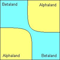
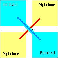
But then you just create the same problems in reverse. Which is where the diplomats trot out the "sovereign flyover". Imagine that they divided the country up like this:
You might not see how this can help. But consider this: There is usually a strip of "no-mans" land along frontiers, between the two sets of border posts. So at the point where the borders cross it will look like this:
Now imagine that you build a road from the north-east and south-west, connecting the Alphan areas, and then another road from the north-west to the south-east, connecting the Betan areas. The Betan road goes over the top of the Alphan road on a flyover (an elevated highway). Something like this:
There are no connections between the two roads. You then do a bit of clever legal work, to define that the Alphan road is Alphan sovereign territory, whilst the Betan road vertically above it, is Betan territory. So both Alphan and Betan citizens can drive from one part of their country to another, without ever leaving their territory or crossing over a frontier. Of course, in reality it wouldn't be quite that simple, especially when a bunch of Betan kids stop on the flyover to drop rocks onto the Alphan cars below, but that's nothing that the permanent presence of a battalion of UN peacekeepers couldn't solve. Copyright � 2002 Critical Miss Gaming Society |